
Drone Flight Zones in Cyprus: Where Can You Fly Your Drone?
Flying a drone in Cyprus can offer spectacular views of the island, from the coastline and mountains to cities, villages and archaeological sites. But before taking off, there is one question every drone operator should ask: Am I allowed to fly my drone here?
The answer is not determined simply by looking at an ordinary map. Cyprus has officially designated UAS geographical zones, also known as drone geo-zones, which identify areas where drone operations are prohibited, restricted or subject to specific conditions.
To make this information easier to understand geographically, cadastral.maps.cy provides a map-based visualisation of the Cyprus drone flight zones using geographical-zone information published by the Department of Civil Aviation (DCA) through its official UAS portal.
This article explains what these zones mean, why they exist, how they affect drone operators and what you should check before every flight.
Important: The information in this article is provided for general information and map-visualisation purposes. Drone operators should always check the latest official information published by the Cyprus Department of Civil Aviation before conducting a flight. Geographical zones can be amended, added or removed.
What are drone geographical zones?
A UAS geographical zone is a defined area where specific rules apply to drone operations.
Under the European Union's drone regulatory framework, Member States can establish geographical zones for reasons including:
- aviation safety;
- national security;
- privacy;
- environmental protection;
- protection of sensitive infrastructure; and
- other specific operational risks.
Depending on the zone, drone operations may be completely prohibited, permitted only under certain conditions, or require prior authorisation.
This system is established under Article 15 of Commission Implementing Regulation (EU) 2019/947, which provides the legal framework for UAS geographical zones throughout the EU.
Cyprus has established its national geographical zones under K.D.P. 190/2024, subsequently amended by K.D.P. 123/2025 and further amended by K.D.P. 3/2026.
The important practical consequence is simple:
Being in the Open Category does not automatically mean that you can fly anywhere.
A drone operation can satisfy all the requirements of the Open Category and still be prohibited or restricted because the intended flight location falls within a geographical zone.
The Cyprus Drone Zone Map
The official Cyprus UAS geographical zones are published digitally and can be represented on a map as circles or polygons.
This is particularly useful for planning a flight because restrictions are location-dependent.
Instead of asking only:
"What type of drone do I have?"
you also need to ask:
"Where exactly am I planning to fly?"
The geographical location can introduce additional restrictions even when your drone and operation otherwise meet the requirements of the Open Category.
The drone-zone map available through cadastral.maps.cy is intended to make this geographic information easier to explore alongside the cadastral and mapping information available on the platform.
When using the map, users should inspect the zone affecting their intended flight area and, where applicable, review the zone administrator and access conditions.
Prohibited and restricted zones
One of the most important distinctions when reading a drone map is the difference between a prohibited area and a restricted area.
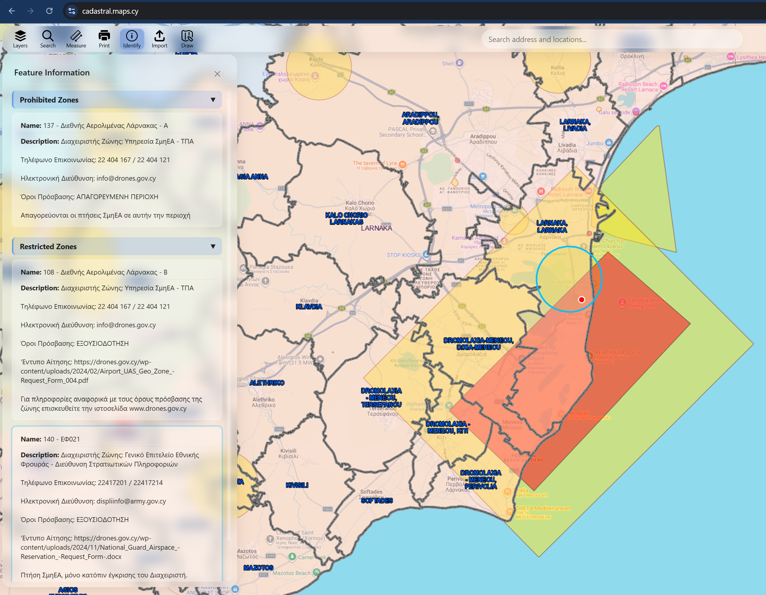
Prohibited zones
In a prohibited zone, the applicable rules do not permit the relevant drone operation.
For example, the current Cyprus airport geographical-zone information identifies areas immediately around the runways of Larnaca and Paphos International Airports where UAS operations are strictly prohibited because the risk of encountering manned aircraft is considered very high.
A pilot should therefore never assume that a small or lightweight drone can be flown simply because it is below 250 grams.
The geographical restriction still matters.
Restricted zones
A restricted zone does not necessarily mean that drone operations are impossible.
Instead, operations may be allowed only after fulfilling specific conditions or obtaining permission from the authority or administrator responsible for the zone.
The conditions depend on the particular geographical zone.
This is why a drone map should not be interpreted simply as:
Red = never fly, yellow = probably okay.
The actual access conditions associated with each zone are what determine what the operator must do.
Why are airports surrounded by drone restrictions?
Airports are one of the clearest examples of why geographical zones are necessary.
A drone sharing airspace with an aircraft can create a serious aviation safety risk. Even a relatively small unmanned aircraft can pose a hazard to an aircraft operating close to an airport.
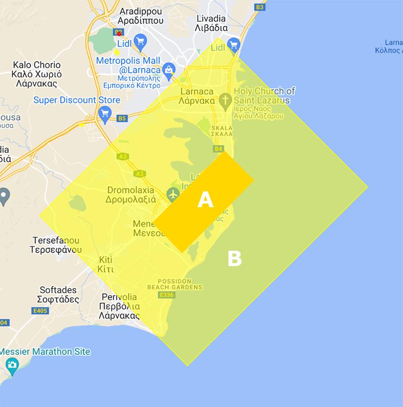
Cyprus therefore establishes specific geographical zones around its two main international airports:
- Larnaca International Airport
- Paphos International Airport
The current DCA information identifies two principal areas around each airport.
Area A – Prohibited
Area A is the area closest to the airport's runway environment.
UAS operations in this area are strictly prohibited because of the high risk of encountering manned aircraft.
Area B – Restricted
Area B covers a larger area around the airport.
Drone operations in this zone are restricted and require the appropriate authorisation from the Department of Civil Aviation.
The current DCA airport guidance also specifies requirements concerning the submission of an airport airspace reservation request and third-party liability insurance for operations within the restricted airport zone.
Because administrative requirements can change, operators should always use the latest application forms and instructions published by the DCA rather than relying on an old application or information copied from another website.
Military and National Guard areas
Airports are not the only reason for drone restrictions in Cyprus.
The national geographical-zone framework also includes areas associated with national security and the National Guard.
Some of these areas can be subject to particularly strict restrictions.
The DCA's geographical-zone information identifies the relevant zone administrator and provides information on how access may be obtained where operations are permitted.
For this reason, a drone pilot should not rely exclusively on the airport map.
A location away from an airport can still fall within another restricted or prohibited geographical zone.
Other sensitive locations
European UAS legislation allows Member States to establish geographical zones for a variety of safety, security, privacy and environmental reasons.
- Depending on the national framework, geographical restrictions can be associated with locations such as:
- airports and heliports;
- military installations;
- national-security infrastructure;
- critical infrastructure;
- protected environmental areas;
- industrial facilities;
- hospitals;
- prisons;
- areas where emergency operations are taking place; and
- other sensitive locations.
The exact restrictions applicable in Cyprus are determined by the current national geographical-zone dataset and the relevant legal instruments.
This is one reason why checking a current geo-zone map before every flight is more reliable than relying on a generic "drone no-fly zone" map found online.
Drone zones are not the same as DJI geofencing
This is an important distinction for drone operators.
Many modern drones contain a geo-awareness or geofencing system that can warn pilots about certain areas.
However, the information displayed by a drone manufacturer's application should not automatically be assumed to represent the legally applicable Cyprus geographical zones.
The Cyprus Department of Civil Aviation specifically warns that the pre-installed geographical-zone information on many DJI drones may not be the correct Cyprus dataset.
The DCA publishes an official Geo Zones JSON file for Cyprus.
For applicable drone classes, operators are required to download the official geographical-zone dataset and upload it to the drone's geo-awareness system when the drone supports this functionality.
Therefore:
A drone application saying that you can fly somewhere does not override a legal restriction published by the competent authority.
The legal geographical-zone information takes priority.
The official Cyprus Geo Zones JSON file
One of the most useful aspects of the Cyprus system is that the geographical zones are not available only as a static map.
The DCA provides the information in a digital JSON format.
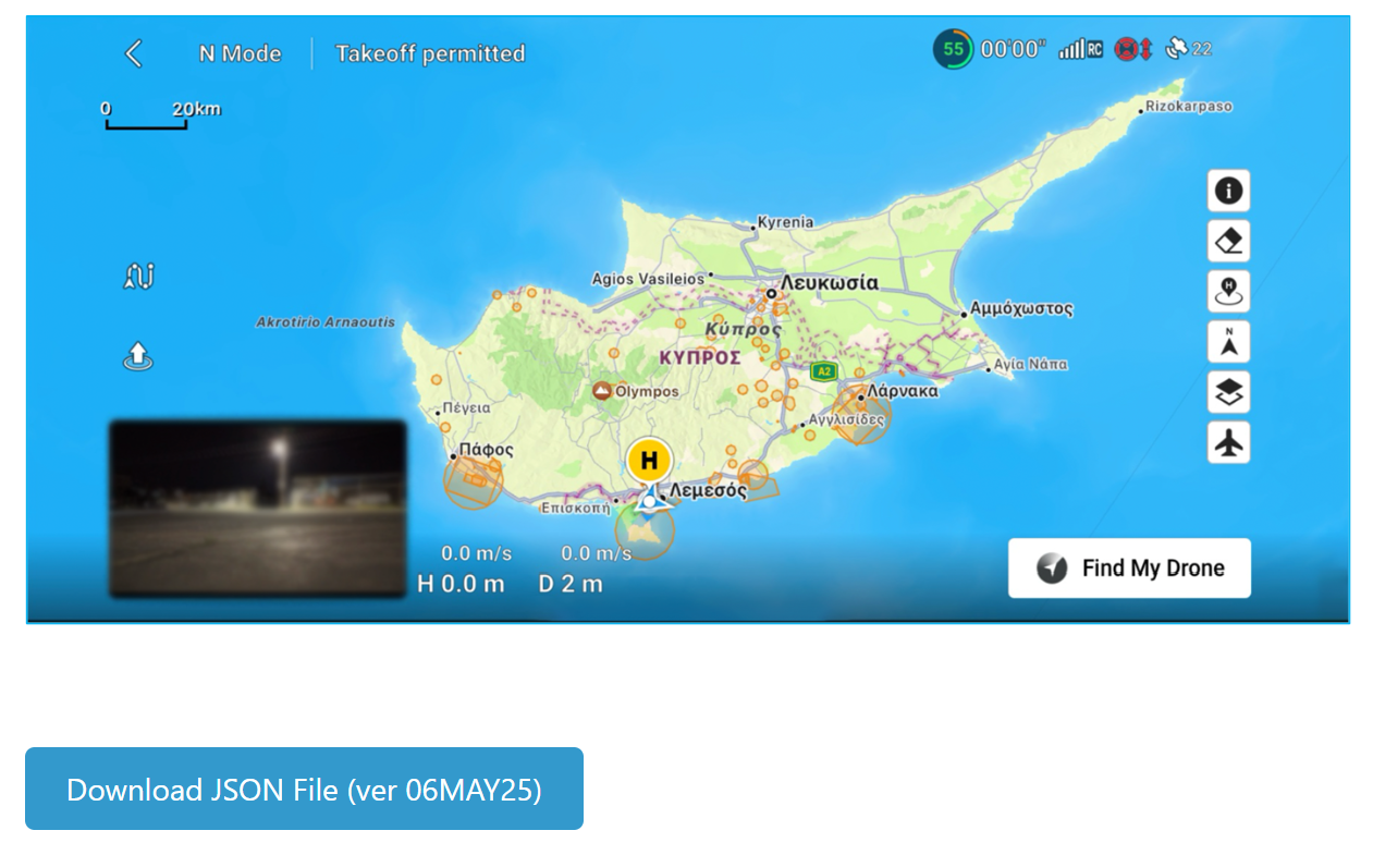
This allows geographical-zone information to be incorporated into compatible geo-awareness systems.
The current DCA website identifies the current downloadable dataset as:
CYP Geo Zones JSON – version 01JAN26
The DCA also provides instructions for importing the file into compatible DJI systems.
This is particularly relevant for drones in classes C1, C2, C3, C5 and C6, for which the DCA states that the geographical-zone map must be uploaded to the drone's geo-awareness system where the functionality is available.
Drone manufacturers other than DJI may have different procedures for importing or updating geo-zone information.
What are the basic Open Category rules?
Geographical zones are only one part of the rules governing drone flights.
Under the EU UAS regulatory framework, the Open Category is intended for lower-risk drone operations and is divided into three subcategories:
A1 – flying close to or, under certain conditions, over people
A2 – flying close to people
A3 – flying far from people
The applicable subcategory depends on factors including the drone's class, weight and the circumstances of the operation.
The Open Category also has important operational limitations.
Among the general requirements are:
- keeping the drone within visual line of sight (VLOS), unless the applicable rules provide otherwise;
- maintaining the required distance from people;
- not flying over assemblies of people;
- keeping within the applicable maximum altitude;
- following the manufacturer's instructions;
- respecting geographical zones; and
- not carrying dangerous goods or dropping material.
The standard maximum height in the Open Category is generally 120 metres from the closest point of the earth's surface, subject to the detailed rules and any geographical-zone restrictions that may impose a lower limit.
Therefore, even if you are flying a small recreational drone, the 120-metre limit and geographical-zone restrictions still need to be considered.
Do I need to register my drone?
Drone registration and pilot requirements depend on the drone and the operation.
For example, many drones equipped with cameras require the operator to register even when the drone weighs less than 250 grams, unless the applicable exception applies.
The Cyprus DCA provides registration and training information through its official UAS portal.
For many common drones in the C1, C2 and C3 classes, operator registration and pilot competency requirements apply.
The exact requirements should therefore be checked according to:
- the drone's class;
- its maximum take-off mass;
- whether it has a camera or other sensor;
- the subcategory of operation; and
- the intended flight operation.
What if my flight is not allowed in the Open Category?
Not every drone operation can be conducted under the Open Category.
Higher-risk operations may fall under the Specific Category.
Examples can include operations outside the limitations of the Open Category, such as certain Beyond Visual Line of Sight (BVLOS) operations or operations involving higher-risk circumstances.
In the Specific Category, an operator may need an operational authorisation, a declaration under an applicable Standard Scenario, or another regulatory pathway depending on the operation.
However, there is an important distinction:
Operational authorisation is not necessarily the same as geographical-zone permission.
A drone operator may have an operational authorisation for a particular operation and still need separate permission to operate within a geographical zone.
The authority responsible for the geographical zone may impose its own access conditions.
This distinction is particularly important when planning professional drone operations.
How to check a location before flying
A good pre-flight process should be straightforward.
1. Identify your drone
Check:
- drone class;
- weight;
- camera/sensor;
- registration requirements;
- pilot competency requirements.
2. Identify your intended flight area
Determine the exact location where the drone will operate.
For larger projects, do not check only the take-off location. Consider the entire intended flight area and trajectory.
3. Check the Cyprus geographical-zone map
Use the current official Cyprus DCA geographical-zone information.
You can also use the drone-zone visualisation on cadastral.maps.cy to explore the location geographically.
4. Inspect the applicable zone
If a geographical zone overlaps your intended flight area, examine:
- zone type;
- restrictions;
- altitude limitations;
- zone administrator;
- contact information;
- authorisation requirements;
- validity period; and
- any other conditions.
5. Obtain permission if required
If the zone requires prior authorisation, obtain the necessary permission before starting the operation.
Do not treat the fact that a drone can physically take off as evidence that the flight is legally permitted.
6. Check for temporary restrictions
Permanent geographical zones are not necessarily the only restrictions affecting a flight.
Temporary restrictions, aviation information, NOTAMs and emergency situations can also affect the airspace.
7. Perform the normal pre-flight safety checks
Finally, check the weather, aircraft condition, battery status, surroundings, people, obstacles and other airspace users.
Why a map matters
Drone regulations are inherently geographic.
A rule such as "do not fly within a particular area" is difficult to understand without seeing the area on a map.
This is where GIS becomes particularly useful.
By displaying the geographical-zone polygons and circles on an interactive map, a pilot can immediately understand how a restriction relates to:
- roads;
- buildings;
- parcels;
- towns;
- airports;
- coastlines;
- landmarks; and
- other geographic features.
The cadastral.maps.cy map provides this geographic context by bringing the drone-zone information into an interactive mapping environment.
This does not change the legal status of the official data. Instead, it provides another convenient way to understand the spatial relationship between a proposed flight location and the applicable geographical zones.
A note about cadastral.maps.cy
The drone geographical-zone information displayed on cadastral.maps.cy is based on data published by the Cyprus Department of Civil Aviation.
The map is intended as a visualisation and planning aid.
Because regulatory information can change, users should always verify the latest information with the competent authority before conducting an actual drone operation.
In particular, users should not assume that an older screenshot, cached map, downloaded dataset or third-party application represents the current legal situation.
Before you fly: a simple checklist
Before launching a drone in Cyprus, ask yourself:
✓ Is my drone compliant with the applicable EU/Cyprus requirements?
✓ Am I registered as a drone operator if registration is required?
✓ Do I have the required pilot training or certificate?
✓ Have I checked the current Cyprus UAS geographical zones?
✓ Is my flight area inside a prohibited or restricted zone?
✓ If permission is required, have I obtained it?
✓ Am I respecting the applicable altitude and distance limitations?
✓ Can I maintain visual line of sight?
✓ Are there people, vehicles, buildings or other obstacles that I need to consider?
✓ Are there temporary restrictions or emergency operations in the area?
If the answer to any of these questions is unclear, the safest approach is to stop and verify the applicable requirement before taking off.
Final thoughts
Drone flying in Cyprus is not simply a matter of finding an open piece of land and launching a drone.
The airspace above that location may be subject to restrictions because of an airport, military installation, critical infrastructure, environmental protection, public safety or another legally designated geographical zone.
The EU regulatory framework provides the overall structure, while Cyprus defines and administers its national geographical zones through the competent authorities.
For drone pilots, the most important habit is therefore simple:
Check the geographical zones before every flight.
The interactive drone-zone map on cadastral.maps.cy is designed to make that geographic check easier by allowing users to explore the restrictions in their spatial context.
However, always use the latest information from the Cyprus Department of Civil Aviation as the authoritative source before conducting a flight.
Official sources
1. Cyprus Department of Civil Aviation – UAS Cyprus
2. Cyprus Department of Civil Aviation – UAS Geographical Zones
3. Cyprus Department of Civil Aviation – Geo Zones JSON
4. Cyprus Department of Civil Aviation – Airport Geographical Zones
5. European Union Regulation (EU) 2019/947
6. European Union Aviation Safety Agency (EASA) – UAS geographical zones
7. Cyprus K.D.P. 190/2024
8. Cyprus K.D.P. 123/2025
9. Cyprus K.D.P. 3/2026